Islamabad: The Pakistan Space and Upper Atmosphere Research Commission (Suparco) has announced the scheduled launch of Pakistan’s new remote sensing satellite (PRSS) on July 31 from the Xichang Satellite Launch Centre in China.
This advanced satellite is designed to significantly enhance the country’s earth observation capabilities, providing high-resolution imaging and critical data for a wide range of national applications.
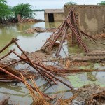
According to a statement issued by Suparco, the satellite will play a vital role in climate disaster prediction and mitigation, helping authorities monitor and respond to natural hazards such as floods, earthquakes, landslides, glacier melt, and deforestation. This data will support early warning systems and informed decision-making for disaster response and environmental protection.
The satellite will also aid urban planning, precision agriculture, resource management, and environmental monitoring, offering valuable geospatial insights to improve development strategies and land use planning across the country.
In addition, the PRSS satellite will contribute to geospatial mapping and infrastructure planning under major national initiatives, including the China-Pakistan Economic Corridor (CPEC), making it a key component in Pakistan’s development agenda.
The upcoming launch strengthens Suparco’s existing satellite fleet, which includes PRSS-1 (launched in 2018) and EO-1 (launched in January 2025). This addition reflects the long-term goals outlined in Pakistan’s national space policy and Vision 2047, aiming to establish the country as a capable and forward-looking spacefaring nation.
Suparco hailed the launch as a technical and strategic milestone in Pakistan’s evolving space journey, with broad implications for national security, environmental resilience, and sustainable development.
Samra Zulfiqar, a real estate analyst at Zameen.com, is passionate about finding projects that offer buyers the best returns. Her keen insights spotlight the market’s most promising opportunities.